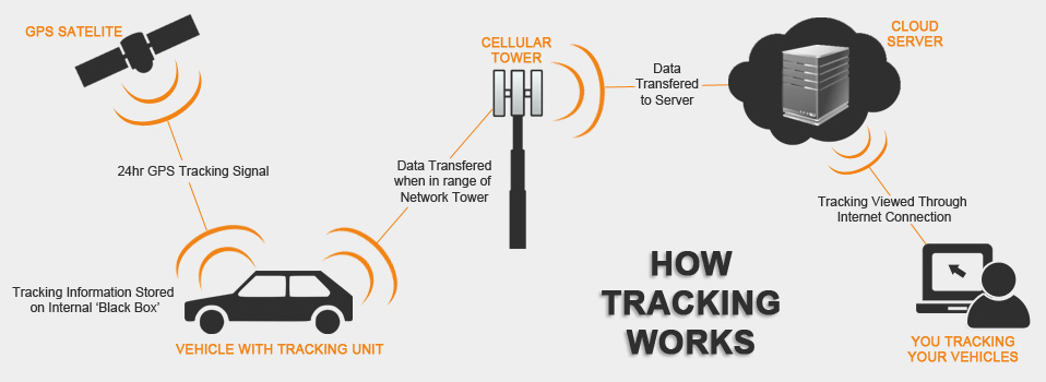
How does GPS work?
There are 24 satellites NAVSTAR In Earth orbit such a way that from any point of the earth's surface was visible from four to twelve of these satellites. The satellites constantly send signals about their GPS location.
Special device, mounted on your vehicle, usually called GPS tracker, receives that signals from satellites, calculates the location of the vehicle and stores it. GPS tracker transmits information about vehicle location on a special server using mobile Internet , where it is subsequently stores. That's how GPS monitoring works.
User can connect to the server at the any time with a personal computer, laptop, tablet or smartphone, and analyze the collected information. That makes GPS monitoring indispensable and universal.

How much time does server store the information?
To handle location information, we use several powerful servers that look like a one piece for the user. That allows us to store information on our servers at least for 6 months.
Information about what events can I get from a GPS tracker?
In addition to information about the vehicle location, modern GPS trackers can collect and transmit information about the speed of the vehicle, the level of voltage in the vehicle's on-board network, the position of the key in the ignition switch, the temperature, the fuel level in the tank, the engine speed, the fact of opening / closing of the door or the lifting of the body dump truck, etc. To collect the expanded information, you may need to purchase additional components.
Why do you need an additional fuel level sensor?
Comparison of the poured into the tank amount of fuel, received from the fuel level sensor system with the accounting documents from the fuel station, or decreasing the fuel level in the tank during the parking of the vehicle allow You to detect the time and place of abuses with the fuel.
If the car has a standard fuel level sensor with a digital output, it can be connected to a GPS tracker too. Additional high-precised fuel level sensor can be installed on the vehicle, which allows you to measure the amount of fuel in the fuel tank to within 1-2% while standart fuel level sensor provides accuracy of no more than 10%.
What can a vehicle monitoring program do?
The vehicle monitoring program allows you to track vehicle online and to work with information from the archive. Vehicle locations and their routes are displayed using Google Maps, 2GIS, OpenStreet, Ovi, Visicom, or Bing. That program allows you to create various reports on the work of vehicle, which shows the mileage, the list and duration of stops, the location and amount of fueling, the vehicle speed, etc. The features of the program are very large and provide all the usual needs. If you want to combine GPS monitoring data and, for example, accounting, into the one information system, we will give yours IT professionals exceptional opportunities.
How to install a vehicle monitoring program?
One of the modern Internet browsers (Mozill Firefox, Google Chrome, Opera, etc.) that are probably installed on your computer, laptop or smartphone is used to access the vehicle monitoring program. No any additional software is required.
Who will help me to understand the vehicle monitoring program?
The vehicle monitoring program is simple and does not require a long studying. A short 15-minute processing of the manuals is enough to get started. Anyway, if after processing the manual or later you have a questions, you can ask our technical support by telephone or by e-mail.